
UniTraQ GT-3731R Manuel utilisateur

UniTraQ International Corp. RoHS compliance.
2007, Version 1.1
Technical Manual
USB GPS Receiver Series
Model:GT-3731R
UniTraQ International Corp. All right reserved, © 2006
9F-2, No 158, Sec. 2, Gongdao 5th Rd., Hsinchu City 30070, Taiwan, R.O.C.
TEL:886-3-5710727 FAX:886-3-5751365
MADE IN TAIWAN

UniTraQ International Corp. RoHS compliance.
2007, Version 1.1
Contents
1. Features…………………………………………………………………………………………………………...1
2. Specifications…………………………………………………………………………..…….…. ……………….2
3. GPS status indicator…………………………………………………………………………………………3
4. Communication specification……………………………………………………………….…………………..3
5. Environment specification………………………………………………….…….…….…………………..4
6. Pin assignment………………………………………………………………….…………………..4
7. Mechanic dimension…………………………………………………………………………………………….5
8. Customized package…………………………………………………………………………………………..5
9. Approved NMEA message…………………………………………….….……..………….………………….6
9.1 GGA – global positioning system fix data…………….………………………….….. ……………….6
9.2 GLL – latitude and longitude, with time of position fix and status……………… ………………..7
9.3 GSA - GPS DOP and active satellites…………….….….….….…….…..….….………………………..8
9.4 GSV - GPS satellite in view………….….….….….….…..….….….….….….……….………………….9
9.5 RMC – recommended minimum specific GPS/transit data…………. .….….…...…………………..10
9.6 VTG – course over ground and ground speed…………….….….….….……..….………………….11
9.7 ZDA – time and data…..….….….….….…..….….….….….….….….….…...….….….………………….11
9.8 Binary messages.….….….….….….…….….….….….….….….….….….….….….….………………….11
Eastern Star 7 series GT-3731R
GPS Receiver

UniTraQ International Corp. RoHS compliance.
2007, Version 1.1
1. FEATURES
z44 channels to acquire and track
satellites simultaneously
zIndustry-leading TTFF speed
zSignal detection better than -158 dBm
zSBAS (WAAS/EGNOS) capable
zCold start < 45sec
zHot start < 1sec
zAccuracy 5m CEP
zUSB Interface
zEasy-plug-in Notebook
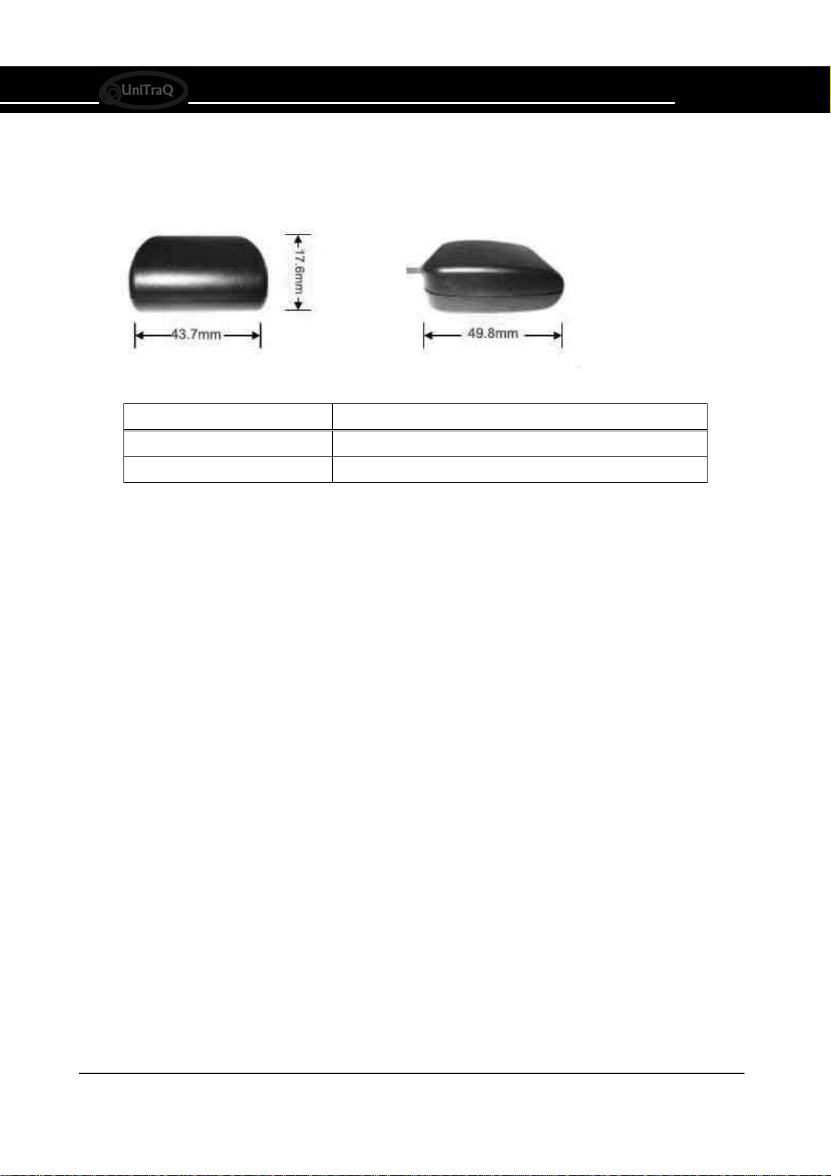
z49.8 mm x 43.7 mm x 17.6 mm
zRoHS compliance
GT-3731R
Fast Acquisition Enhanced Sensitivity
44 Channels USB Interface GPS Receiver
The GT-3731R is a compact all-in-one GPS receiver that
continuously tracks all satellites in view and provides
accurate satellite positioning data.
Its 44 parallel channels and 20000+ correlators provide fast
satellite signal acquisition and short start-up time. Acquisition
sensitivity of -155dBm and tracking sensitivity of -158 dBm
offer good performance even under difficult environments.
The GT-3731R is optimized for applications requiring good
performance and low cost; it is suitable for a wide range of
handhelds, asset tracking, Notebook, PDA-centric personal
navigation system, and vehicle navigation products.
1
Eastern Star 7 series GT-3731R
GPS Receiver

UniTraQ International Corp. RoHS compliance
2007, Version 1.1
2
Eastern Star 7 series GT-3731R
GPS Receiver
2. SPECIFICATIONS
Parameter Specification
Receiver Type 44 channels
Re-acquisition sensitivity -155dBm
Tracking sensitivity -158dBm
Cold start sensitivity -137dBm
Receiver frequency 1575.42MHz
Code C/Acode
Accuracy
(1) Position
(2) Velocity
5m CEP
0.1m/sec
Startup Time
hot start
warm start
cold start
< 1 sec
< 35 sec
< 45 sec
Signal Reacquisition <1s
Update Rate 1Hz
Operational Limits
(1) Altitude
(2) velocity
< 18,000m
< 500m/s
Dynamics 4G (39.2m/sec2)
Datum WGS-84
Protocol NMEA-0183 V3.01
Serial Interface USB interface
Input Voltage 5V ±5%
Power Consumption 180mW
Connector USB B-type 4P male connector with 1.8M cable

UniTraQ International Corp. RoHS compliance
2007, Version 1.1
3
Eastern Star 7 series GT-3731R
GPS Receiver
3. GPS STATUS INDICATOR
The GT-3731R provides GPS status indicator. LED On board shows fix or non-fix. In fix mode, the LED
will light for 1second and turn off for 1second. In another mode, the pin will light for 2 seconds and turn off for
2 seconds.
4. COMMUNICATION SEPECIFICATIONS
Item Description
Interface Full duplex serial interface
Bit rate 4800/9600bps
Start bit 1bit
Stop bit 1bit
Data bit 8bit
Parity none
Transmission data SACII NMEA0183 Ver:3.01
Update rate 1Hz
Output sentence GGA/GSA/GSV/RMC

UniTraQ International Corp. RoHS compliance
2007, Version 1.1
4
Eastern Star 7 series GT-3731R
GPS Receiver
5. ENVIRONMENT SPECIFICATION
Parameter Specification
Operating -20℃~+60℃
Temperature Storage -40℃~+80℃
Humidity 5%~95%
6. PIN ASSIGNMENT
PIN Signal name Description Notes
1 VCC USB port power 5V
2 D- USB port data-
3 D+ USB port data+
4 GND USB ground
UniTraQ International Corp. RoHS compliance
2007, Version 1.1
5
Eastern Star 7 series GT-3731R
GPS Receiver
7. MECHANIC DIMENSION
Parameter Specification
Physical dimension 49.8mm X 43.7mm X 17.6mm
Weight 14g
8. CUSTOMIZED PACKAGE
zColor box
zCD (including user manual, USB driver and GPS test program)

UniTraQ International Corp. RoHS compliance
2007, Version 1.1
6
Eastern Star 7 series GT-3731R
GPS Receiver
9. APPROVED NMEA MESSAGE
The serial interface protocol is based on the National Marine Electronics Association’s NMEA 0183 ASCII
interface specification. This standard is fully define in “NMEA 0183, Version 3.01” The standard may be
obtained from NMEA, www.nmea.org
9.1 GGA – GLOBAL POSITIONING SYSTEM FIX DATA
Time, position and fix related data for a GPS receiver.
Structure:
$GPGGA,hhmmss.sss,ddmm.mmmm,a,dddmm.mmmm,a,x,xx,x.x,x.x,M,x.x,M,x.x,xxxx*hh<CR><LF>
1 2 3 4 56 7 8 9 10 11 12 13
Example:
$GPGGA,060932.448,2447.0959,N,12100.5204,E,1,08,1.1,108.7,M,,,,0000*0E<CR><LF>
Field Name Example Description
1 UTC Time 060932.448 UTC of position in hhmmss.sss format, (000000.00 ~
235959.99)
2 Latitude 2447.0959 Latitude in ddmm.mmmm format
Leading zeros transmitted
3 N/S Indicator N Latitude hemisphere indicator, ‘N’ = North, ‘S’ = South
4 Longitude 12100.5204 Longitude in dddmm.mmmm format
Leading zeros transmitted
5 E/W Indicator E Longitude hemisphere indicator, 'E' = East, 'W' = West
6 GPS quality
indicator
1 GPS quality indicator
0: position fix unavailable
1: valid position fix, SPS mode
2: valid position fix, differential GPS mode
3: GPS PPS Mode, fix valid
4: Real Time Kinematic. System used in RTK mode with
fixed integers
5: Float RTK. Satellite system used in RTK mode. Floating
integers
6: Estimated (dead reckoning) Mode
7: Manual Input Mode
8: Simulator Mode
7 Satellites Used 08 Number of satellites in use, (00 ~ 12)
8 HDOP 1.1 Horizontal dilution of precision, (00.0 ~ 99.9)
9 Altitude 108.7 mean sea level (geoid), (-9999.9 ~ 17999.9)
10 Geoid Separation Geoid separation in meters according to WGS-84 ellipsoid
(-999.9 ~ 9999.9)
11 DGPS Age Age of DGPS data since last valid RTCM transmission in
xxx format (seconds)
NULL when DGPS not used
12 DGPS Station ID 0000 Differential reference station ID, 0000 ~ 1023
NULL when DGPS not used
13 Checksum 0E
Note: The checksum field starts with a ‘*’ and consists of 2 characters representing a hex number. The
checksum is the exclusive OR of all characters between ‘$’ and ‘*’.

UniTraQ International Corp. RoHS compliance
2007, Version 1.1
7
Eastern Star 7 series GT-3731R
GPS Receiver
9.2 GLL - LATITUDE AND LONGITUDE, WITH TIME OF POSITION FIX AND STATUS
Latitude and longitude of current position, time, and status.
Structure:
$GPGLL,ddmm.mmmm,a,dddmm.mmmm,a,hhmmss.sss,A,a*hh<CR><LF>
1 2 3 4 5 6 7 8
Example:
$GPGLL,4250.5589,S,14718.5084,E,092204.999,A,A*2D<CR><LF>
Field Name Example Description
1 Latitude 4250.5589 Latitude in ddmm.mmmm format
Leading zeros transmitted
2 N/S Indicator S Latitude hemisphere indicator
‘N’ = North
‘S’ = South
3 Longitude 14718.5084 Longitude in dddmm.mmmm format
Leading zeros transmitted
4 E/W Indicator E Longitude hemisphere indicator
'E' = East
'W' = West
5 UTC Time 092204.999 UTC time in hhmmss.sss format (000000.00 ~ 235959.99)
6 Status A Status, ‘A’ = Data valid, ‘V’ = Data not valid
7 Mode Indicator A Mode indicator
‘N’ = Data not valid
‘A’ =Autonomous mode
‘D’ = Differential mode
‘E’ = Estimated (dead reckoning) mode
‘M’ = Manual input mode
‘S’ = Simulator mode
8 Checksum 2D

UniTraQ International Corp. RoHS compliance
2007, Version 1.1
8
Eastern Star 7 series GT-3731R
GPS Receiver
9.3 GSA - GPS DOP AND ACTIVE SATELLITES
GPS receiver operating mode, satellites used in the navigation solution reported by the GGAor GNS
sentence and DOP values.
Structure:
$GPGSA,A,x,xx,xx,xx,xx,xx,xx,xx,xx,xx,xx,xx,xx,x.x,x.x,x.x*hh<CR><LF>
1 2 3 3 3 3 3 3 3 3 3 3 3 3 4 5 6 7
Example:
$GPGSA,A,3,01,20,19,13,,,,,,,,,40.4,24.4,32.2*0A<CR><LF>
Field Name Example Description
1 Mode A Mode
‘M’ = Manual, forced to operate in 2D or 3D mode
‘A’ =Automatic, allowed to automatically switch 2D/3D
2 Mode 3 Fix type
1 = Fix not available
2 = 2D
3 = 3D
3 Satellite used 1~12 01,20,19,13,,,,,
,,,, Satellite ID number, 01 to 32, of satellite used in solution,
up to 12 transmitted
4 PDOP 40.4 Position dilution of precision (00.0 to 99.9)
5 HDOP 24.4 Horizontal dilution of precision (00.0 to 99.9)
6 VDOP 32.2 Vertical dilution of precision (00.0 to 99.9)
7 Checksum 0A
Table des matières
Autres manuels UniTraQ GPS

UniTraQ
UniTraQ UD-731 Manuel utilisateur

UniTraQ
UniTraQ BT-5721 Manuel utilisateur

UniTraQ
UniTraQ GT-525 Manuel utilisateur

UniTraQ
UniTraQ BT-771 Manuel utilisateur

UniTraQ
UniTraQ UD-731 Manuel utilisateur

UniTraQ
UniTraQ BT-5721 Manuel utilisateur

UniTraQ
UniTraQ MT-900M Manuel utilisateur
UniTraQ
UniTraQ UD-731N Manuel utilisateur


